Geology
Mar 21, 2026
Geochemistry
Geophysics
Historical Geology
Mineralogy
Petrology
Physical Geology
The ‘Ghost Fault’ Under Hubbard Glacier: What the M7.0 Alaska-Yukon Earthquake Actually Revealed
A shallow M7.0 earthquake near Hubbard Glacier did more than shake a remote corner of the St. Elias Mountains. It confirmed a fault scientists had modeled beneath ice, explained wh
This earthquake was dramatic not because it hit a city, but because it exposed a piece of tectonic architecture that had been mostly invisible. The December 6, 2025 magnitude 7.0 event near Hubbard Glacier did not just produce strong shaking and hundreds of slope failures. It confirmed that a long-suspected fault beneath ice is real, active, and important for future hazard in the Alaska-Yukon border region.
That deeper layer matters because the most interesting story is not simply that a big quake happened. It is why this specific fault broke here, and what the still-unruptured part may be capable of next.
Where the earthquake happened — and what it was not
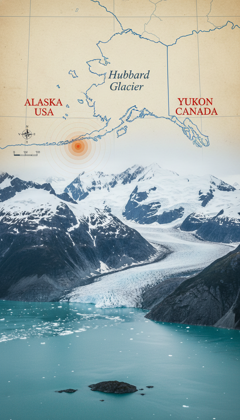
A common misconception is that this was an “Alaska earthquake” in the coastal subduction zone. In fact, the epicenter was in Yukon, Canada, in the remote St. Elias Mountains near the Alaska border, roughly 60 miles north of Yakutat. It was also not primarily a tsunami-generating megathrust event.
The quake occurred in continental crust on an oblique-slip strike-slip fault, meaning the blocks moved mostly sideways with some additional vertical or compressional component. That fits the messy tectonic setting here: the Yakutat terrane is colliding with southern Alaska, creating what geologists sometimes describe as a tectonic “train wreck” of compression, sideways motion, uplift, and fault transfer.
Because the rupture was inland and strike-slip dominated, the main hazards were strong shaking, landslides, avalanches, and ongoing slope instability — not major coastal inundation.
Why the Connector Fault mattered so much
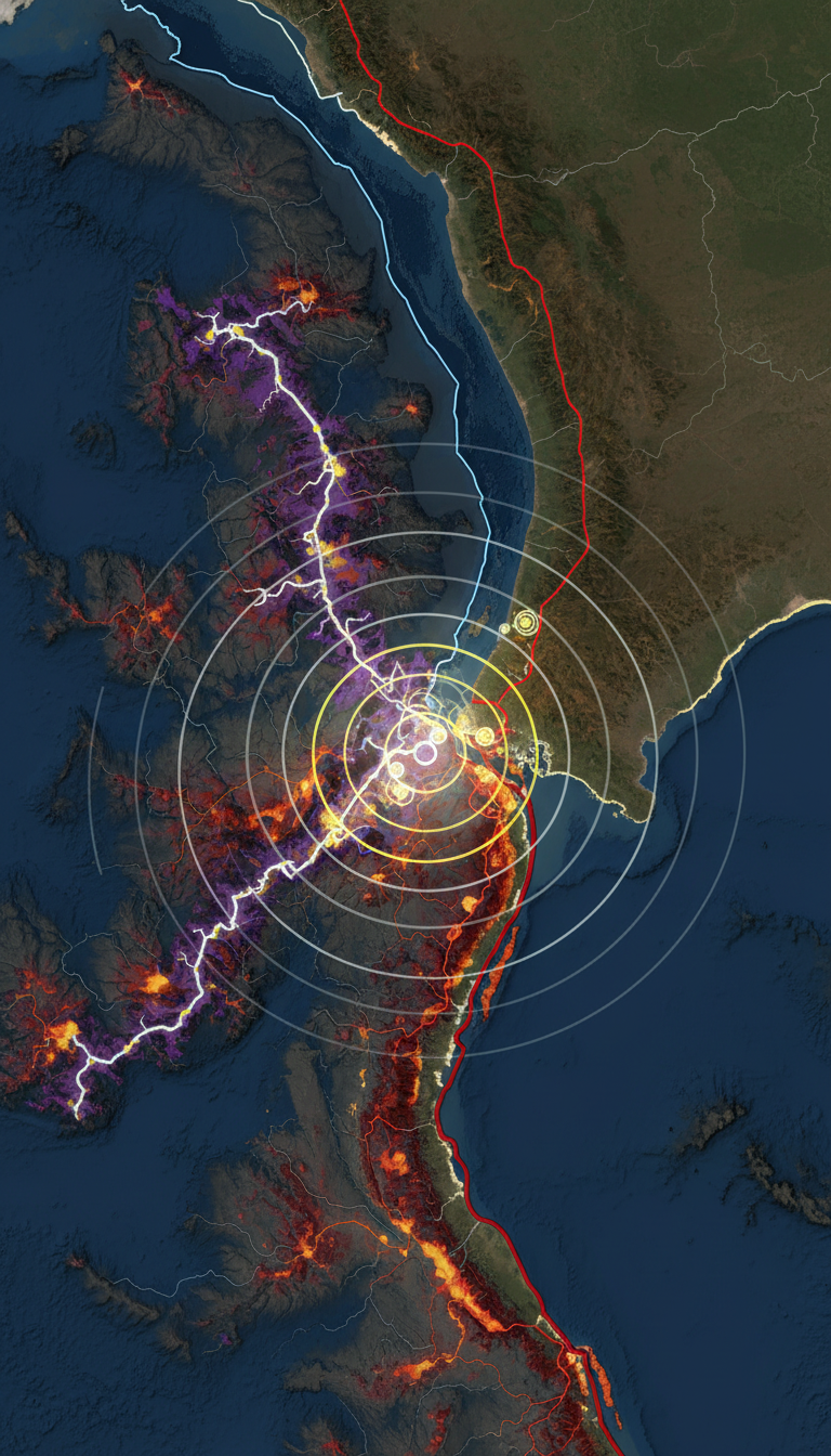
The most important scientific result is that the earthquake ruptured about 50 km of the southern end of the Connector Fault, a roughly 250 km strike-slip structure long hypothesized to link the Fairweather and Totschunda fault systems. Much of it lies beneath glacier ice, especially around Hubbard Glacier, which is why it remained a kind of “ghost fault.”
Explore our free geology courses

Geochemistry: Principles and Applications
Free course

Geophysics Fundamentals and Applications
Free course
Historical Geology: Earth's Past Through Time
Free course

Introduction to Mineralogy
Free course
Petrology: Igneous, Sedimentary, and Metamorphic Rocks
Free course
Physical Geology
Free course
So how did scientists know a hidden fault was there before it broke? They did not see a clean surface trace through the ice. Instead, they assembled multiple lines of evidence:
- regional plate-motion patterns showing a need for a transfer structure
- mapped fault segments at either end that appeared geometrically connected
- landscape and geophysical clues around the glacier margins
- hazard models, including recent USGS work, that treated the Connector as a likely active source
That is why this quake is such a striking validation: a fault included in modern hazard thinking appears to have ruptured almost exactly where models suggested it could.
How scientists traced a fault they still could not fully see
Even without a dramatic open crack across the glacier surface, the rupture effectively drew itself after the fact. The aftershock zone lined up along the hidden structure, “painting” a coarse fault trace beneath Hubbard Glacier. Satellite observations also showed a narrow, rupture-aligned band of intense slope failure.
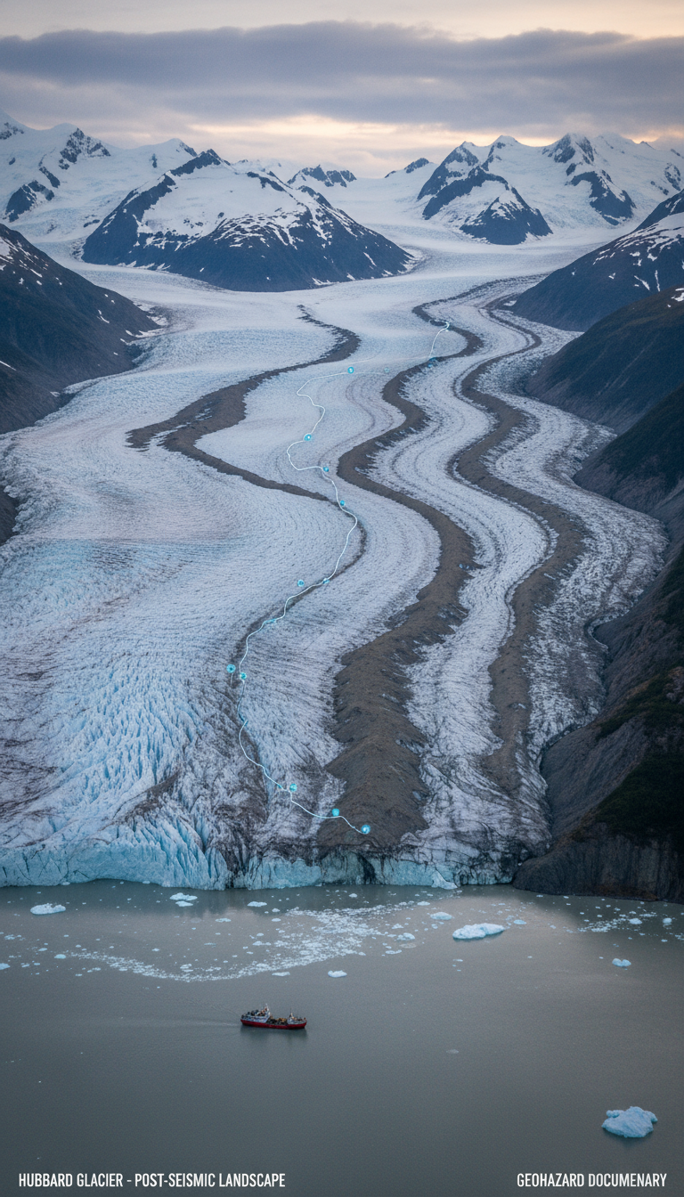
More than 700 landslides and snow avalanches were triggered, many concentrated in a corridor about 16 km wide. At least 21 were very large, over 2 km long, and some ran more than 3.5 miles from high peaks including the Mount Logan area. In steep glaciated terrain, that pattern is exactly what strong, prolonged shaking would produce, especially from a shallow M7 event.
In other words, the landslides were not just secondary drama. They were evidence. They helped outline where shaking was strongest and supported the interpretation of a buried, linear rupture source.
Why this quake happened here
The mechanism comes down to strain transfer in a collision zone. The Fairweather fault system carries major right-lateral motion along the coast. Farther inland, the Totschunda fault also accommodates strike-slip motion. The Connector Fault appears to bridge part of that system through the St. Elias region, where crust is being both squeezed and sheared.
That combination favors oblique slip: sideways rupture with a compressional component. A glacier can hide the surface expression, but it does not stop stress from accumulating in the rock below. Over decades to centuries, enough strain built up for a 50 km segment to fail.
What the unruptured section could mean next
The biggest unresolved hazard question is whether the remaining roughly 150 km unruptured section of the Connector Fault is segmented into smaller pieces or capable of breaking in a larger event. If it is relatively continuous, that raises the possibility of an earthquake on the order of M7.5, though that is not a prediction — only a physically plausible scenario that scientists will now test with better data.
This matters because the quake will refine recurrence estimates and shaking forecasts for places that are not on top of the rupture but could still be affected, including Whitehorse, Haines, and Skagway. It also matters for Hubbard Glacier itself: debris loading, ice fracturing, and altered slope conditions may influence glacier behavior, though those effects will take time to measure.

Bottom line
This earthquake answered one major question and opened another. It showed how scientists knew a hidden fault was there before it ruptured: by combining tectonic geometry, geophysics, landscape clues, and hazard modeling. And it showed what the remaining unruptured section could mean: a newly sharpened seismic risk that may include larger future rupture scenarios, depending on how that buried fault is segmented.
For now, the event stands as a rare case where a glacier-covered “ghost fault” moved from hypothesis to confirmed reality in a single earthquake.